Log in
All resources
Create a design
11,660 Free Images of Old Map
baroque
bibliothèque nationale de france
maps by willem and johannes blaeu
atlas van loon
old maps of sluis
maps of polders in zeeland
gemeente atlas van nederland - zeeland
maps of paris from paris musées
musée carnavalet
maps in the british museum
maps by willem and johannes blaeu
copper engravings
maps of paris from paris musées
plan de turgot
old maps of dendermonde
atlas van loon
maps of paris by braun & hogenberg
maps of paris from paris musées
maps made in the 17th century
old maps of gelderland
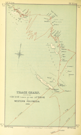
wanderings, south and east (1882)
old maps of polynesia
old maps of woerden
davidt vingboons
maps in the british museum
old maps of dunkerque
old maps of freiburg im breisgau
emery walker
maps of utrecht (city) city walls
old maps of utrecht (city)
maps of paris from bibliothèque nationale de france
dheulland map of paris
maps in the library of congress
novus atlas sinensis
maps from the earth and its inhabitants, vol. x
maps of port said
maps from the earth and its inhabitants, vol. x
1890s maps of the nile delta
atlas maior, vol 6 (scotland and ireland) - joan blaeu, 1667 - bl 114.h(star).6
1667 maps
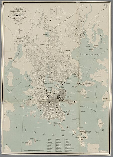
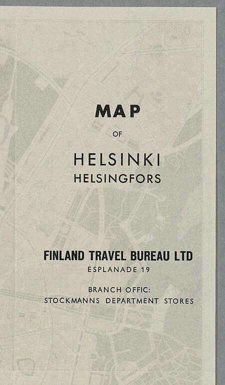
media from the national library of finland
classicism
maps of polders in zeeland
old maps of sluis
old maps of zwolle
atlas van loon
palatinatus rheni (merian)
baroque
palatinatus rheni (merian)
baroque
maps of polders in zeeland
old maps of sluis
palatinatus rheni (merian)
baroque
maps of polders in zeeland
old maps of sluis
old maps of the republic of genoa
maps of the duchy of milan
everett d. graff collection of western americana
stephen f. austin
maps of brussels city walls
old maps of brussels
maps from the earth and its inhabitants, vol. iv
1880s maps of england
maps in the library of congress
old maps of barbados
bodleian maps collection
old maps of oxford
old maps of the tribes of israel
guillaume sanson
maps in the rijksmuseum amsterdam
published by frans buffa & zonen
gemeente atlas van nederland - south holland
old maps of delft
gemeente atlas van nederland - north holland
old maps of haarlem
maps of paris from bibliothèque nationale de france
nouveau plan de paris by louis brion de la tour
old maps of manchuria
general atlas (1773)
gewerbe-ausstellung für rheinland, westfalen und benachbarte bezirke
old maps of düsseldorf
maps by jakob van der schley
old maps of kollam
strasbourg in the 17th century
old maps of strasbourg
cartes de franz schrader
maps of algeria by theme
historisk atlas (stockholm, norstedt & söner, 1880)
old maps of the polish-lithuanian commonwealth
old maps of the stations of the exodus
joan blaeu
maps of tournai city walls
old maps of tournai
maps of polders in zeeland
old maps of sluis
bibliothèque municipale de reims, rès. g 152
old maps of abbeville
plan de la ville et faubourg de paris, divisé en ses 48 sections by mondhare & jean
maps of paris from bibliothèque nationale de france
old maps of culemborg
atlas van loon
old maps of blankenberge
flandria illustrata
nypl collection of atlases, gazetteers, guidebooks and other books
nypl lionel pincus and princess firyal map division
illustrations from découverte de la terre
19th-century maps of cities
john rocque's 1746 map of london
marlborough house, london
maps by willem and johannes blaeu
old maps of the peloponnese
media from the national library of finland
classicism
sixth map of paris from traité de la police
maps of paris from paris musées
old maps of heraklion
baroque
19th-century maps of crimea
g. h. swanston
english-language maps
maps by john cary
gemeente atlas van nederland - north holland
old maps of alkmaar
typus orbis terrarum
1570 maps of asia
old maps of south africa
1879 maps of africa
carte de la mer mediterranée (1764) by roux
eran laor cartographic collection
old maps of hannover
1757 in hannover
catalan atlas
mansa musa
old maps of gelderland
atlas van loon
maps of moers by johannes mercator
old maps of duisburg
1710s maps of eastern europe
muscovy
old maps of schweinfurt
baroque
merian sueviae
baroque
old maps of sierra leone
1662 maps
turgot map of paris – derivative files
old maps of île saint-louis
old maps of samegrelo
cornelis de jode
english-language maps
1747 maps of asia
fort rammekens in art
old maps of zeeland
maps from the earth and its inhabitants, vol. x
1890s maps of egypt
details of old maps of amsterdam
map of amsterdam, 1625
prints by agostino veneziano in the british museum
maps in the british museum
prints by agostino veneziano in the british museum
maps in the british museum
17th-century maps of saxony
old maps of vogtland
old maps of sas van gent
sassevaart
maps of paris from the david rumsey historical map collection
proletarian literature
engravings of topographia helvetiae, rhaetiae et valesiae
old maps of st. gallen
description de l'universe
old maps of asia
maps in the library of congress
1720s maps of palestine
atlas des anciens plans de paris by imprimerie nationale, 1900 from the david rumsey historical map collection
maps of paris from the david rumsey historical map collection
atlas des anciens plans de paris by imprimerie nationale, 1900 from the david rumsey historical map collection
maps of paris from the david rumsey historical map collection
palau in the 18th century
old maps of palau
gemeente atlas van nederland - utrecht
maps of oudewater
maps of the history of sweden
old maps of scandinavia
maps by christian sgrothen
old maps of north holland
bern city map of 1638 by matthäus merian
baroque
merian sueviae
baroque
old maps of the bay of gibraltar
18th-century maps of gibraltar
cartes de franz schrader
old maps of algiers
tōzai ezo sansen chiri torishirabezu
oshima peninsula
media from the national library of finland
classicism
gemeente atlas van nederland - north holland
old maps of haarlem
maps from the earth and its inhabitants, vol. xii
canary islands in the 1890s
jan karel donatus van beecq
hernán cortés
maps of philippsburg city walls
old maps of philippsburg
bibliothèque municipale de reims, rès. g 152
1656 maps of france
engravings of topographia palatinatus rheni
baroque
7801 - 7900 of 11,660
Next page
/ 117


![[Agas map of Oxford, 1578], Augustine Ryther](https://cdn.creazilla.com/illustrations/10001154709/agas-map-of-oxford-1578-augustine-ryther-md.jpg)


![Sixth plan of the city / of Paris / And its increases, from the beginning of the Reign of Charles / VII, the year 1422, until the end of the Reign of Henry III, the year 1589 [1705], Antoine Coquart](https://cdn.creazilla.com/illustrations/10000442243/sixth-plan-of-the-city-of-paris-and-its-increases-from-the-beginning-of-the-reign-of-charles-vii-the-year-1422-until-the-end-of-the-reign-of-henry-iii-the-year-1589-1705-antoine-coquart-sm.webp)